By Marty Graham, Contributor
Photos by Noah Berger
CALFIRE Captain Scott McLean, who fought fires for more than 25 years before he became a spokesman, was heading home from his assigned station when his wife called and told him he should go back to work. “She said, ‘Turn around and look,’ and I saw an enormous cloud of smoke from Paradise,” he says.
What he saw at the Camp Fire was of an intensity like nothing he’d ever seen before. “The Camp Fire was not normal, it wasn’t just a fire front,” he says. “Embers scattered much farther than usual. The strong wind was pushing it right to dry fuel.”
McLean encountered his first evacuee on his way in to the burning town. A woman in a wheelchair with a puppy on her lap came rolling through the thick smoke in front of him. He took her to safety. “The first day, all we did was evacuate,” he says. Though it’s hard to grasp that there was little point to trying to stop or contain the fire, there are times that happens. “Our world is rugged and unforgiving.”
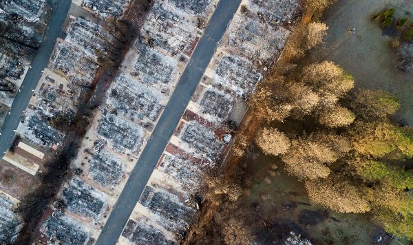
After touring the devastation, like the mobile home park pictured above, California governor Gavin Newsom came away understanding the new realities of fighting wildfires: that they spread faster, burn hotter, and are more difficult to fight than ever before. That’s why, on January 8, 2019, his first official day in office, Newsom committed $105 million to reduce the danger of wildfires that have devastated California communities in the past two years. The money—in addition to buying helicopters—will advance a new way to fight wildfires: with data.
After touring the Camp Fire devastation, California governor Gavin Newsom committed $105 million toward a new way to fight wildfires: with data and transformative technology.
California has long had wildfires that swept through its national forests and neighborhoods built at the edge of cities and in the back country. And as more frequent bouts of dangerously dry weather, combined with drought that dries out new brush quickly, wildfires have become savage. The need for a faster and more focused response, better warning systems, and the ability to get ahead of fires has never been more pronounced.
More experts from around the world are turning to data to predict, prepare for, and manage the disasters that follow fire, including dense smoke, landslides, and the spread of toxins from ash and other materials transformed by fire. In this pivotal moment in wildfire history, California’s investment is speeding up research and leading the charge to fight fire through transformative technology.
‘Feels Like Magic’
The Los Angeles Fire Department (LAFD) began using WIFIRE, an integrated system for wildfire analysis, in 2014. Use of this smart technology will now expand with access to some of Newsom’s funds.
The WIFIRE platform, which handles the enormous task of making sense of massive data from many sources in real time, is a game changer for the people behind the scenes. Assistant Chief Carlos Calvillo at LAFD calls it one of the most useful tools he’s seen in his career. Getting information in real time, he notes, feels like magic.
WIFIRE, an integrated system for wildfire analysis, has been a game changer for the Los Angeles Fire Department. This smart technology delivers detailed information in real time.
“It gives us information that’s more detailed and precise in that initial phase of the fire, when things are fluid and moving very quickly and there isn’t a management team set up,” Calvillo says. “This is a very useful tool—fast and easy to use—that can assure or reassure an incident commander that they’re making the right decisions when placing resources or asking communities to evacuate their homes.”
Also a public platform, WIFIRE has millions of hits from viewers watching while cities from Santa Rosa to Malibu burn. More versatile still, the firefighters’ version lets users run scenarios and, most importantly, predict what will happen in the next minutes. Los Angeles County, Ventura County, and Orange County fire departments have committed to signing on this year.
Recent developments build on a legacy of innovation. Ilkay Altintas, chief data scientist at the San Diego Supercomputer Center, and her team first launched the WIFIRE project in 2013 with seed money from the National Science Foundation. Focused on volume and efficiency, the team built a comprehensive data management structure that could handle workflows of enormous amounts of data–topography, weather conditions, historic fire behavior, for starters—and provided critical information that was less than 15 minutes old.
Yet in the last year, WIFIRE has become far more precise because the platform’s power has been ramped up to include fresh, current data that’s being crunched quickly with machine learning. It has also been beefed up with data and processes that help predict what firefighters call the “PIG” (the probability of ignition) created by wind-scattered, fire-spreading embers. In addition, the platform now includes census data to identify where people are. Finally, fire study is also increasingly turning to social media to gather information, as well as share it.
“The predictions are coming out faster and bigger, ” Calvillo says. “The accuracy and timeliness of the program are great, and we’re getting information that helps us do more and do it sooner.”
The View From (Way) Up High
While L.A. was an early adopter of this technology, Calvillo says his department wasn’t always so sure of its value—the team’s data mapping expert, who now embraces the platform, was a skeptic at first.
In addition to initial hesitation among some leadership arms, one of WIFIRE’s biggest challenges, according to Altintas, was getting accurate and timely information about brush. Until recently, the best data they could find was no less than a year old, and a lot can change in a year.
Fortunately, emerging technologies that transform satellite information are delivering data far faster and with more detail, according to Kim Slater, systems manager and the business lead for space innovations at Draper, a not-for-profit research and development organization that focuses on creating prototypes that advance new technologies and ideas.
Today, Draper is developing small satellites—as small as 4-inch cubes clustered into groups of three or six—that capture and transmit imagery so precise that license plates are legible from orbit more than 200 miles from Earth. Dozens of those satellites are already in space, and Draper can build more.
“What used to cost hundreds of millions of dollars to fly satellites the size of a school bus now costs tens of thousands of dollars, and they’re the size of a toaster or lunchbox,” Slater says. “We’re now approaching being able to capture images of every place on Earth, every day. In a year or two, we’ll get every place on Earth at least every 10 minutes and in some places, every minute.”
What to do with this monstrous amount of raw data—whether to transmit or sort it— then becomes an important question. Draper is working on optical systems to get the data back to Earth, but the company is also focused on microprocessors that can sort it in space, relying on machine learning to discern meaning. “We do things like teach a computer to look at imagery and start seeing the patterns,” Slater says. “It’s detecting change, that’s the most important part of this,” which brings her back to the fires. The images Draper satellites capture can also be used to help fend off post-fire disasters.
Capturing Toxins After the Fire
When the fire is finally put out, its fallout is just beginning. Not only is the denuded, ash-covered landscape incredibly vulnerable to landslides, the burned material can be full of toxic chemicals and metals that can get into water sources with devastating consequences, explains Jack Webster, an engineer and assistant professor at California State University Chico who studies and measures water quality.
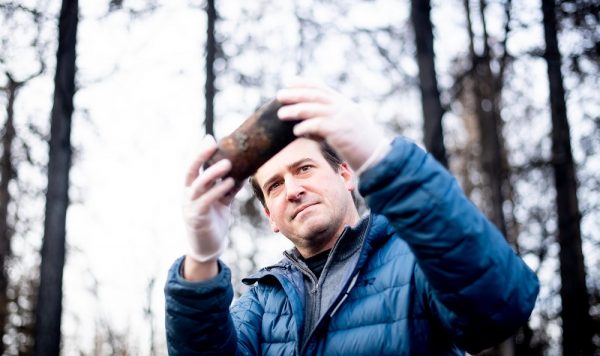
Scientists like Jack Webster, an engineer and assistant professor at California State University Chico (pictured above), are studying the environmental impact following wildfires to help keep toxic metals out of waterways and farmlands.
Fires like the Paradise fire are particularly troublesome because the fire was barely out before the rainy season arrived and began sweeping a harrowing array of metals like lead, mercury, and nickel into creeks, streams, and the local farming water supply.
“There are so many possible contaminants in these structures, in these cars, and in these buildings; the consumer electronics that burned, the solvents and hydrocarbons that were in people’s garages, in auto shops,” he says. “There’s rubber, there are adhesives. There’s vinyl siding and patio furniture. There’s plastics.”
For example, the fire was so hot, it melted aluminum and left it scattered in pools. Aluminum is incredibly toxic to fish, and fish die-off affects the entire ecosystem. Cadmium from batteries is another extremely toxic metal for humans. These chemicals, if swept up and dumped onto farm land, will render the land barren. It’s a long list of things you don’t want mixed into growing human food, Webster says.
That’s where the space data comes back into picture. Imagery from the tiny satellites has the potential to help keep these chemicals and metals out of the water supply because people looking at detailed, high-resolution images will often, over time, be able to identify how the harmful materials are moving after a single day or multiple days of rain.
And if environmental engineers and scientists can see the change—a lot of Earth science moves slowly—then they can get out to the right place to test and to block and catch the water, or at least filter it before it goes into the streams, rivers, and lakes. It’s the difference between sampling scientists with up-to-date information who know where to look for toxins and the scientist who comes to test a spot in a lake once a week, who may not notice that the water is higher, or that there’s an algae bloom or die off somewhere else in the lake. With the satellite technology, images taken hours and days apart can show those changes: a flat spot one day that is part of a moving hillside over the next few days, for example.
“The magic in the new imagery and in the artificial intelligence applications is that you can look at those changes over time.”—Kim Slater, systems manager and space innovations lead, Draper
“We’re working with researchers to develop ways to track this,” Slater says. “The magic in the new imagery and in the artificial intelligence applications is that you can look at those changes over time.”
Fire-spotting
Enormous improvements in underlying data are also helping with novel research on some of the least predictable challenges firefighters face, such as how the fire can generate its own weather—winds, heat, and embers that create sudden, unpredictable, and dangerous conditions.
Tarek Zohdi, a professor of mechanical and micro-mechanical engineering at University of California, Berkeley, launched the Fire Project in November just days after Newsom committed funding. By then, Zohdi was deep into looking for patterns in the piece of WIFIRE he developed. Today, he studies how nightmarish fire-spreading embers and the terrible smoke from fires behave, so firefighters can send people out to the right places and arrive with the right tools.
“Data is going to tell us where smoke will end up, although the data is relatively coarse now,” he says. “Embers, on the other hand, flow stochastically. The models aren’t very complicated, but they are a very different physical effect than fire.”
When Zohdi talks about fire-spotting, he means the seemingly random spread of embers and their behavior. Some cool off and become harmless while they’re flung around; others remain dangerous, in the form of random patterns. Both smoke and embers behave erratically in the face of a number of different forces, Zohdi explains. So, he studies the forces as well as the flaming bits.
“When something is burning, there’s a giant updraft of hot air. When the updraft encounters cooler air moving laterally, the air masses tangle and twirl, creating a turbulent fire,” he says. Yet, with enough data, experts will be able to predict how embers will travel and how dangerous they’ll be when they land.
With enough data, experts will be able to predict how embers will travel and how dangerous they’ll be when they land.
Still, that kind of turbulence can turn into what McLean calls a fire tornado—like the ones that hit Redding, California, during the Summer 2018 Carr fire. The fire seemed to be 40-percent contained until the winds shifted and an unpleasant wildfire turned into a 100-foot wall of fire spewing embers and starting more fire in every direction.
According to McLean, the fire tornado generated winds up to 143 mph, tearing off roofs that then ripped trees—still on fire—out of the ground. In addition to being a dramatic scene, the fire tornado—seen in both the Carr and Paradise fires—spread the disaster much faster and farther than people had seen in their lifetimes. “That’s unusual fire behavior, but not unheard of until this year, when we saw it twice,” he says.
Experts such as Slater and Zohdi believe in the power of data to mitigate some of this fury. However, Zohdi cautions, “There’s no one silver bullet here.”
And while the combination of strategies might not add up to one all-powerful bullet, Zodhi is nonetheless certain of one thing: What looks unpredictable, he explains, can be better understood with data crunching, more precise imaging, and communication.